A Fake Paris Designed by Air Defence
Towards the end of the First World War, with radar still in its infancy, the French military devised a plan to protect the French capital from German aerial bombardment: the creation of a fake Paris. This is a translation of an article describing the plan that appeared in the French weekly news magazine, L’Illustration, on October 2, 1920. The two maps reproduced here, along with their captions, appeared in the original article.
As we move further from the war, it is possible to speak more freely about some of the methods used to try and protect the Paris region against attack from the air, and which up until now remained closely-guarded secrets. One of the strangest, and still one of the least well-known, was the creation of “false targets”, the purpose of which was nothing less than to make enemy pilots believe that the Paris area…was located somewhere else than it really is.
The first trials of decoy lighting were carried out at a location called l’Orme de Morlu, north-east of Saint-Denis1, as early as August 1917. These were very rudimentary, limited to setting up acetylene lamps along several dirt roads to suggest the presence of avenues whose lights had not been turned off. A little later, it was decided to increase the size of this false target by using electric lighting and the area’s existing power lines. But soon, at the behest of Mr. J.-L. Dumesnil2, Under-secretary for Aviation, and under the guidance of General Renaux and Major3 Ducros of Air Defence4, a large-scale plan was drawn up designed to mislead the enemy as to the exact location of Paris. This involved the creation of illuminated targets in carefully-selected areas that pilots might mistake for locations in Paris and its suburbs whose lights has not been turned off.
The difficulties of carrying out this plan were considerable. Firstly, sites whose general topography resembled that of the locations to be reproduced needed to be identified on a map. For example, to replicate Paris and its surroundings it was necessary to use a bend of the Seine similar to the one that passes through the capital, and which no methods of deception could take the place of. Next, areas that were going to be designated for enemy bombardment needed to be sparsely populated or populated as little as possible. Finally, decoy installations needed to be constructed with the utmost secrecy, without which any advantages of the ruse would be lost. After careful study, it was decided to create false targets in three separate areas:
1) A north-eastern zone, based on the industrial outskirts of north-east Paris (the area of Saint-Denis), featuring the installation of train stations, working factories, and roads with street lighting;
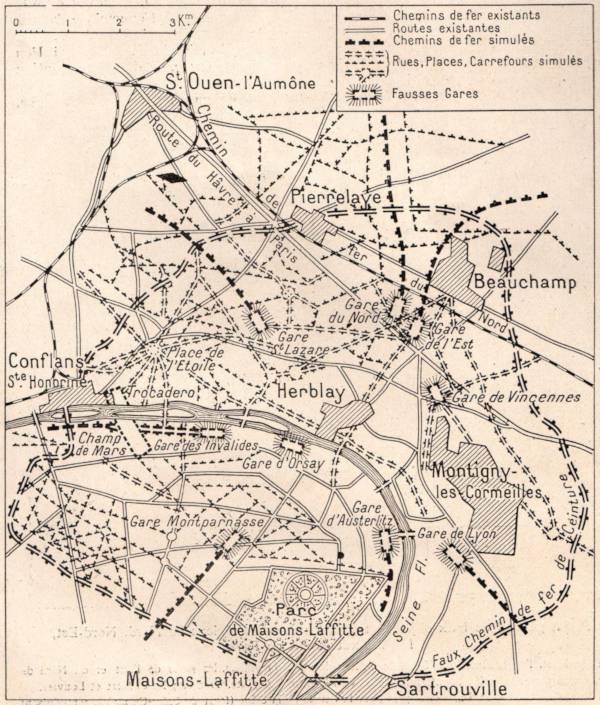
2) A western zone, located south of Pontoise5, using a bend of the Seine to simulate Paris with its railway lines, Petite Ceinture railway6, train stations, main avenues, the Champs-Élysées etc.;
3) An eastern zone around Gournay and Vaires-sur-Marne7, built on the Marne river and forming a group of dummy industrial facilities.
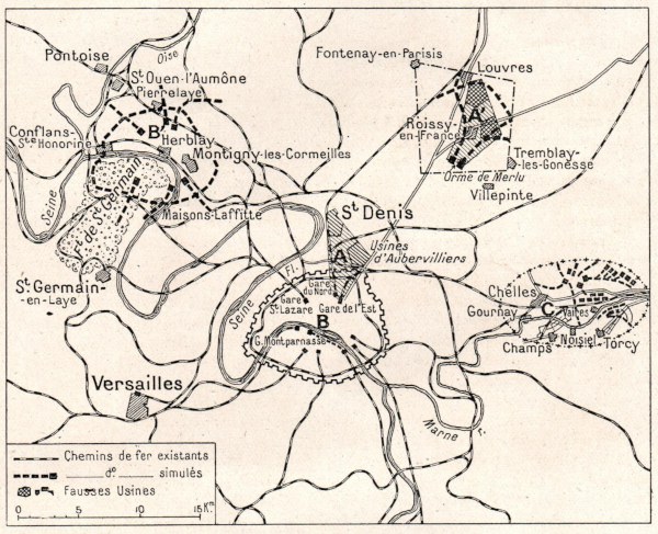
However, Air Defence lacked the resources to implement its plan and it was obliged to approach private industry for help. Trials made at night on Paris’s Champ de Mars and observed from the upper level of the Eiffel Tower showed off decoy lighting methods recommended by an electrical engineer, Mr. Jacopozzi8. It was decided to put these into practice on a large scale as part of the plan that had recently been drawn up. Nevertheless, only one contract was signed for development of the Orme de Morlu area. Contracts for the other two zones (the western zone of Pontoise and that of Gournay-Vaires-sur-Marne) were to be granted only after the results achieved by the first zone could be assessed. The German defeat and the armistice made this unnecessary.
The false target of l’Orme de Morlu
The aim of the “false target of l’Orme de Morlu”, the overall name given to the decoy construction work carried out, was to reproduce a fake Saint-Denis, a fake Aubervilliers9, a fake Gare de l’Est and Gare du Nord10, as well as the factories that crowd this northern suburb of Paris. Firstly, an initial location was chosen. This was a roughly square area indicated by the settlements of Fontenay-en-Parisis, Chennevières-les-Louvres, Tremblay-lès-Gonesse, and Gonesse11. However, the population density of this area meant that a second location was finally chosen. This lay in a hexagon marked by Gonesse, Roissy-en-France, Tremblay-lès-Gonesse, the east of Sevran, Aulnay-sous-Bois, and Le Blanc-Mesnil12. Only a single decoy group was actually built, between Sevran and Villepinte13. The main features of this were a fake Gare de l’Est, with buildings, railway lines, both moving trains and trains waiting at a platform, tracks and signals under construction, and a factory with working furnaces. In addition, it was necessary to create a transformer bank to step down the 15,000 volts power supply of the Société d’Éclairage et Force14 to 110 volts.
But it is the details of the plan’s execution that are the most colourful. To help speed up the construction of buildings, a single model was adopted. These were made up of sections formed by 10-metre wide trusses. The trusses were made from lightweight wood and nailed together rather than assembled using normal methods15 to permit future reuse. These were covered with stretched translucent canvas that was also painted to imitate the dirty glass roofs of factories. They were lit from underneath by a double row of lights, one of which produced a normal level of lighting, while the other simulated the dimmed lighting used during an air raid. Because the illusion could only be created by using such means in a subtle way. Lighting that was overly bright would have quickly been perceived as a clumsy ruse. It was necessary to use sufficient light to attract the attention of enemy pilots, but not so much as to arouse their suspicion. In other words, to make visible lights which appeared as if they were trying to be concealed. Here the work of the electrical engineer needed to be accompanied by an acute understanding of the human mind which, what’s more, underpins the art of deception.
To imitate the glow of sites with working machinery, artificially produced steam was successively lit by different coloured lights (white, yellow, and red). The dummy railway lines were created by simply laying pieces of canvas on the ground, and signals were reproduced using different coloured lights positioned at a height of 2 metres. Trains were represented by wooden shelters placed on the ground and spaced at the width of real carriages. Light was projected sideways from under these surfaces as if it came from carriage windows. But the pièce de résistance was the simulation of a moving train. This dummy construction extended over 2 kilometres, with light moving gradually from one end of this distance to the other along a length equivalent to that of the average train. In a word, the concept of the illuminated signs that were seen on our boulevards before the war had here been cleverly applied. Most of this work was carried out by local personnel, predominantly women, with material arriving in the field ready to be put in place.
If time had not run out
Such, then, was one of the most ingenious and most well-concealed imaginings of the recent war. But there was not enough time to see it through and judge its possible impact. Its success would have undoubtedly hinged on a few specific requirements. It was necessary, for example, to count on a certain lack of composure and critical thinking amongst enemy pilots. But would this not be quite natural in men flying at the dead of night, in the storm of machine gun and artillery fire that their opponent’s defence unleashed around them? The “false targets” were never meant to take the place of the other means used by Air Defence. On the contrary, they could only be used in conjunction with them. If they only succeeded in diverting a small portion of the projectiles aimed at the capital or important structures, it can be assumed that they would have served their purpose.
Interrupted by the military victory, there remains at least the memory of these trials along with some interesting documentation. In particular, the map of this fake Paris that was going to be built in the vicinity of Pontoise. The inhabitants of this peaceful area would be surprised to learn that, by an artful disguise, the Place de l’Étoile and the Avenue des Champs-Élysées were once nearly recreated in their midst!
But could the secret have been kept? On the orders of the General in charge of the German Imperial Air Service16, a pamphlet was written concerning protection against attack from the air. This pamphlet contains a section entitled “dummy installations”, which describes in an almost identical manner the techniques used by our own Air Defence. The pamphlet in question is dated the 1st May 1918, while the French subterfuge plan, the details of which we have just read, had been presented to the Minister of War17 by Mr. Jacopozzi on February the 9th of that year. Does this mean that German spies had gotten hold of this information? That would perhaps be somewhat rash. It is only natural that on both sides, the same needs resulted in similar ruses. In any event, even supposing that the German high command had gotten wind of our efforts, that probably wouldn’t have stopped some enemy pilots from being fooled by the illusion of a fake factory or dummy train station, and that was all that mattered.
Footnotes
1 A city on the northern outskirts of Paris.
2 Jacques-Louis Dumesnil, appointed to government by Prime Minister, Paul Painlevé, on September 12, 1917 and retained by Georges Clemenceau when he became Prime Minster on November 20.
3 In French, commandant, equivalent to a Major in most English-speaking countries.
4 In French, Défense Contre Avions (DCA), the unit designed to protect French territory from aerial attack.
5 A city located 28km to the north-west of Paris.
6 Literally the “small belt”, a circular railway that circumnavigated Paris through its outer arrondissements. Originally opening in 1867, it closed as a passenger service in 1934.
7 Both towns around 20km to the east of Paris.
8 Fernand Jacopozzi (1877-1932), an Italian-born electrical engineer who in the 1920s first illuminated the Eiffel Tower and many other Paris monuments.
9 A town on the north-eastern outskirts of Paris.
10 Literally “Eastern Station” and “Northern Station”, the two train stations in the north-east of Paris.
11 All settlements located north east of Paris. Tremblay-lès-Gonesse changed its name to Tremblay-en-France in 1989. Most of the Paris Charles de Gaulle Airport is now located within its territorial boundary.
12 Roissy-en-France, Sevran, Aulnay-sous-Bois, and Le Blanc-Mesnil are all located north-east of Paris.
13 A town located about 18km north-east of Paris.
14 Literally “Power and Lighting Company”.
15 i.e., instead of employing traditional mortise and tenon joints.
16 The Deutsche Luftstreitkräfte, predecessor of the Luftwaffe.
17 Georges Clemenceau (1841-1929), also French Prime Minister at the time.

A Fake Paris Designed by Air Defence by Aaron Robertson is licensed under a Creative Commons Attribution-NonCommercial 4.0 International License.
Permissions beyond the scope of this license may be available at https://www.aaronrobertson.co/contact/.